Columbia Point
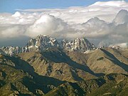
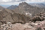
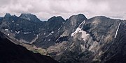
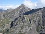
Mountain summit in Colorado, United StatesColumbia Point is a high mountain summit of the Crestones in the Sangre de Cristo Range of the Rocky Mountains of North America. The 13,986-foot (4,263 m) thirteener is located 5.5 miles (8.8 km) east by south of the Town of Crestone in Saguache County, Colorado, United States. The Crestones are a cluster of high summits in the Sangre de Cristo Range, comprising Crestone Peak, Crestone Needle, Kit Carson Peak, Challenger Point, Humboldt Peak, and Columbia Point.
Read article


Top Questions
AI generatedMore questions
Nearby Places
Crestones
Crestone Peak
Mountain in the state of Colorado, United States
Kit Carson Peak
Mountain in the state of Colorado

Challenger Point
Mountain in Colorado, United States

Crestone Needle
Fourteener and twentieth highest mountain in the US state of Colorado (14,203').
Mount Adams (Colorado)
Mountain in Colorado, United States of America
Sangre de Cristo Wilderness
Wilderness area in Colorado, United States

Willow Lake (Saguache County, Colorado)